Mount Rushmore emerging through fog, an unfinished mountain sculpture, heavy spring snow and a Wyoming motel with an extraordinary lobby: our 2010 journey brought plenty of surprises. From the Black Hills, we continued toward Yellowstone through a river canyon and past a broad reservoir, with snowy peaks beyond.
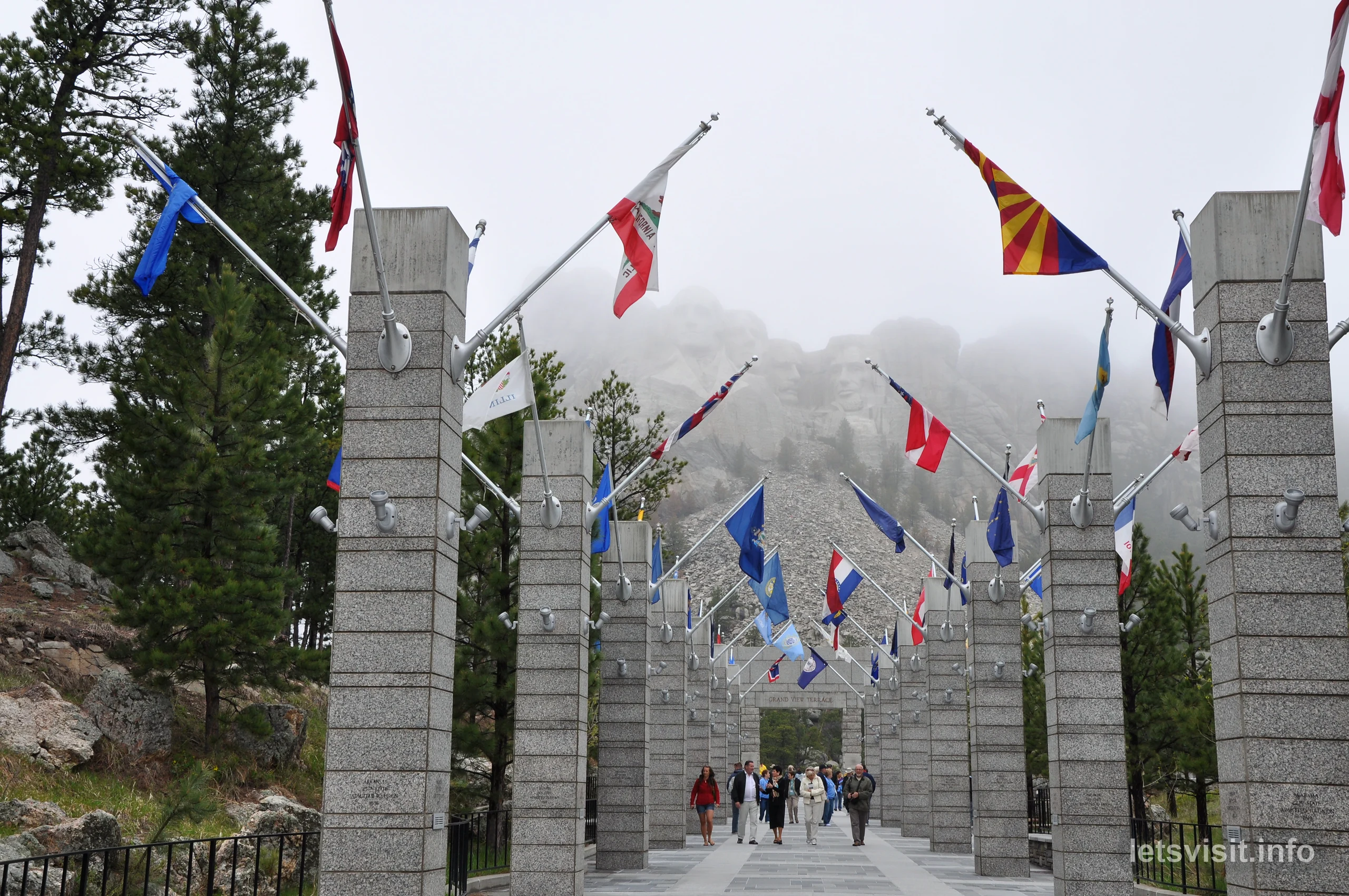
This part of our American trip began among the forested roads of South Dakota’s Black Hills. We traveled along Iron Mountain Road, stopped briefly in Keystone and walked the Avenue of Flags at Mount Rushmore. The four presidents were there, but the weather made seeing them an experience of its own.
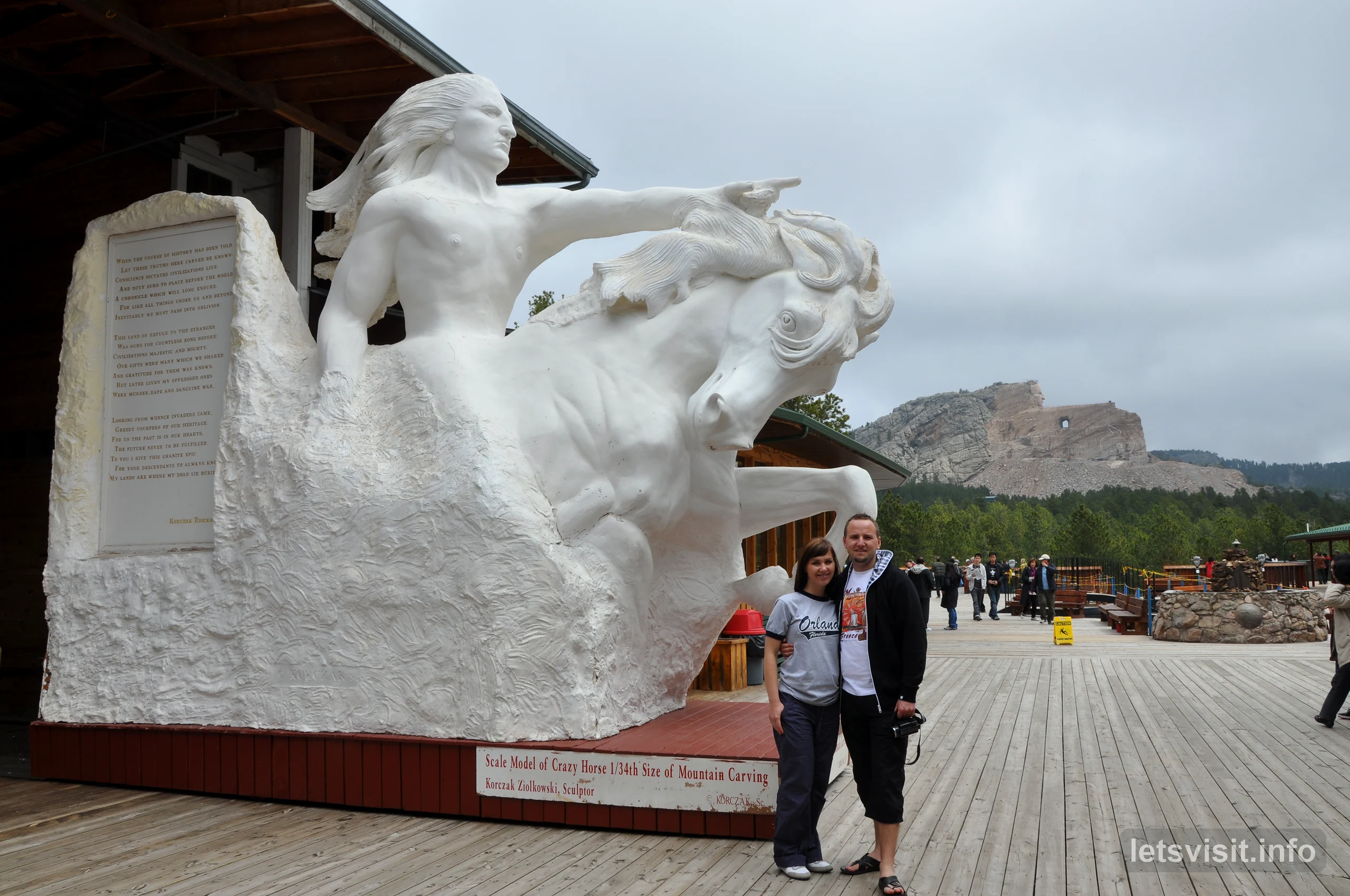
Crazy Horse Memorial gave us another mountain carving to consider, with a model showing the intended composition and the work still underway outside. Farther along the journey, the view from our bus changed from rain to heavy snow. In Wyoming, an unusual motel lobby and the road beside the Shoshone River added some of the most distinctive moments of this part of our trip.
Our journey at a glance
When
Spring 2010
Main stops
Mount Rushmore and Crazy Horse Memorial
On the road
Bus travel through changing mountain weather
Onward through Wyoming
Shoshone Canyon, Buffalo Bill Dam and Wapiti Valley toward Yellowstone
On this page
Our filmIron Mountain RoadMount RushmoreCrazy Horse MemorialSpring snowWyoming motelShoshone CanyonBuffalo Bill DamWapiti ValleyOur memories
Our Mount Rushmore and Wyoming travel film
Our film follows this stretch of the journey from the Black Hills to the road toward Yellowstone. It brings together the monuments and the traveling between them: fog around the carved faces, snow beyond the windshield, the unusual motel lobby and the changing scenery along the river.
Watch our original Mount Rushmore and Wyoming travel film on YouTube.
Iron Mountain Road: curves through the Black Hills
The approach through the Black Hills was an interesting part of the journey in its own right. On Iron Mountain Road, the route bends through the forest and changes height around the terrain. Its wooden pigtail bridges give those curves a form that is easy to recognize.
Iron Mountain Road forms part of the Peter Norbeck National Scenic Byway. Its timber bridges and looping approaches allow the road to negotiate changes in elevation within a confined landscape. Seen among the trees, the structures have a very different character from a broad, straight highway.
There is practical engineering behind the unusual shapes. Cecil Clyde Gideon developed the pigtail bridge designs in 1932, working with Senator Peter Norbeck on the road’s layout. The South Dakota State Historical Society’s account describes both the difficult elevation changes and the intention to give the bridges a rustic appearance.
For us, the curves and timber structures made the drive memorable before we reached the memorial. We also made a brief stop in Keystone, then continued to Mount Rushmore.
Mount Rushmore appearing through the fog
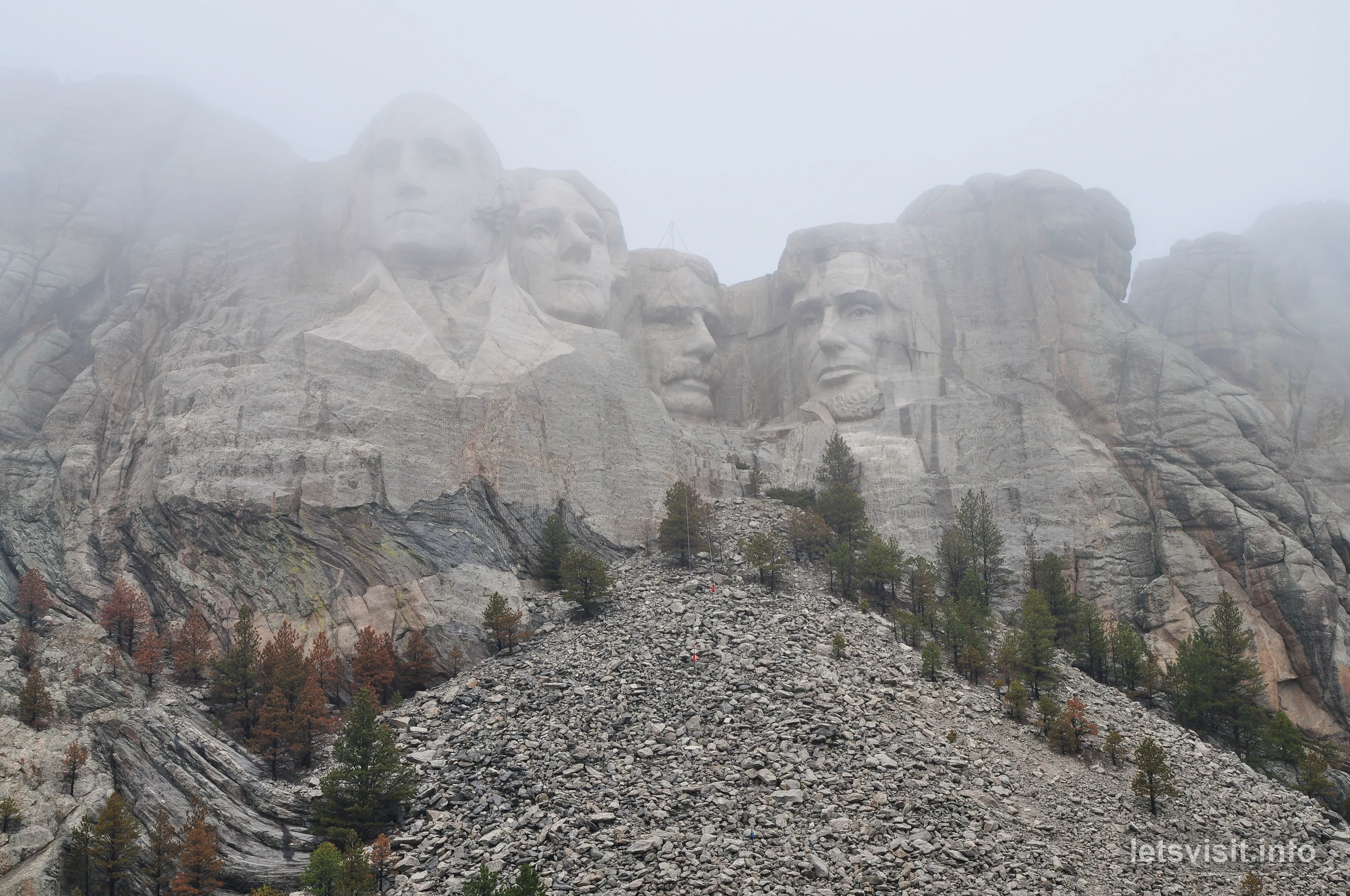
Mount Rushmore was wrapped in thick fog when we arrived. Walking along the Avenue of Flags, we looked toward the mountain as the faces gradually emerged through the mist.
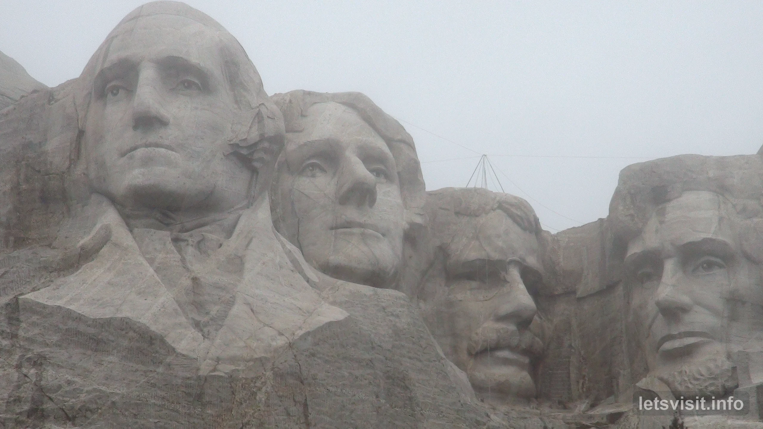
George Washington, Thomas Jefferson, Theodore Roosevelt and Abraham Lincoln became recognizable against the pale background. The fog softened the outlines of the carving and the surrounding rock. Instead of taking in a sharply defined mountain face all at once, we saw the familiar features become clearer through the changing visibility.
That atmosphere is inseparable from our memory of the visit. The presidents remained the focus, but the weather became just as much a part of the scene. Our view of Mount Rushmore belonged to that particular day in the Black Hills.
The dimensions help explain why the carving is so striking even when partly obscured. The presidents’ heads are roughly 60 feet, or 18 meters, tall, although their individual measurements vary.
How the four presidents became a mountain memorial
The carving took place between 1927 and 1941. Sculptor Gutzon Borglum directed the project, and his son Lincoln Borglum supervised the final drilling after his father’s death in 1941. The National Park Service’s chronology records the stages of work and the separate dedications of the figures.
Borglum chose the presidents to represent a particular account of American history. In his intended symbolism, Washington represents the nation’s birth, Jefferson its growth, Theodore Roosevelt its development and Lincoln its preservation.
Knowing that intention adds meaning to the arrangement of faces. It also makes clear that the mountain presents an artist’s selection of people and events, shaped into a public monument.
The Black Hills’ longer history
The setting has a much longer cultural history. The Black Hills hold spiritual and cultural significance for the Lakota and other Native peoples.
The 1868 Treaty of Fort Laramie included the Black Hills within the Great Sioux Reservation. Gold discoveries brought incursions by prospectors, and the United States confiscated the land in 1877, as explained in the National Archives’ account of the treaty.
This history belongs alongside the story of the carving. The presidents are one layer of the landscape’s meaning; the Indigenous relationship with the Black Hills long predates the memorial and continues beyond it.
Crazy Horse Memorial: the mountain and the model
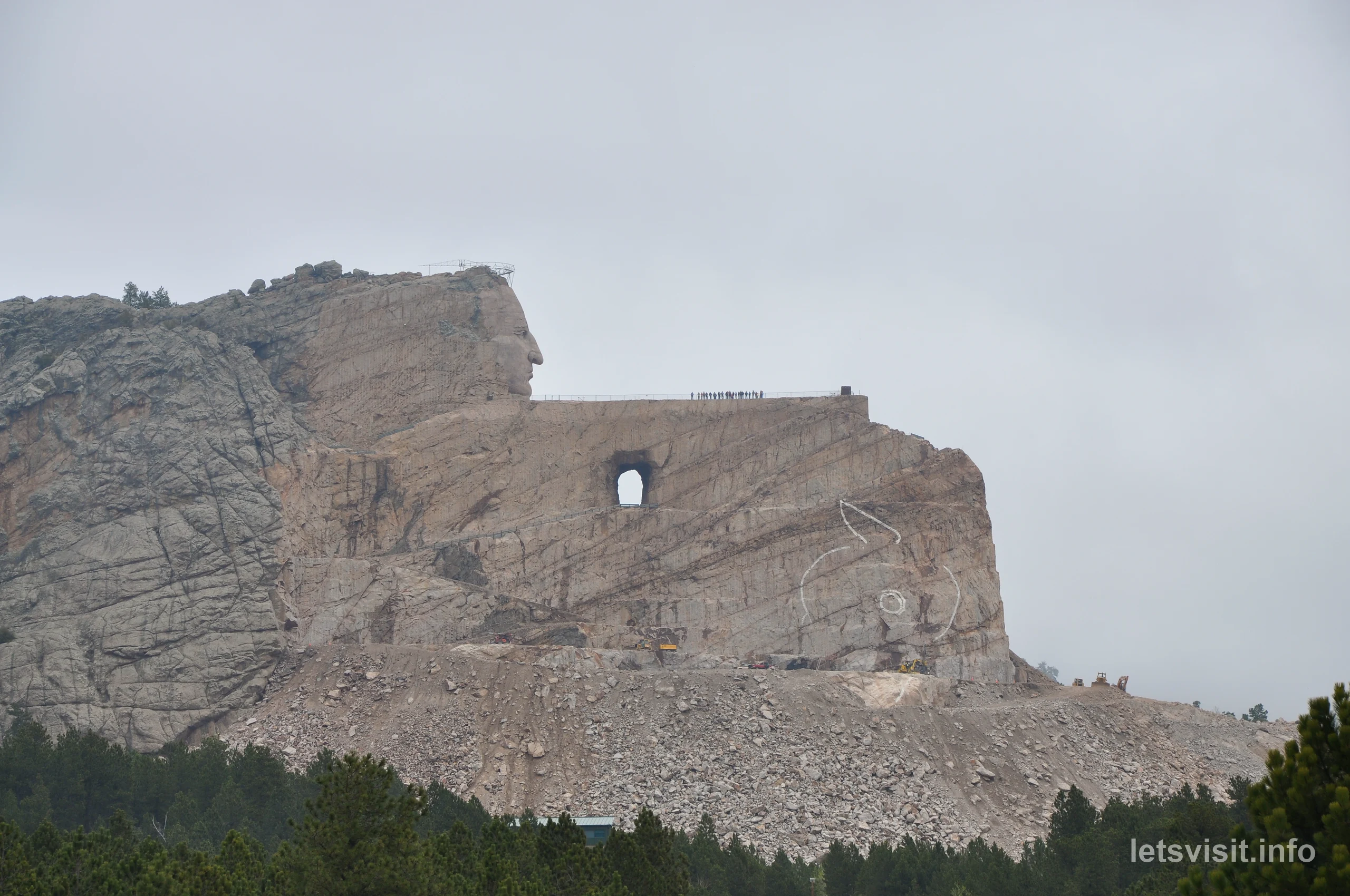
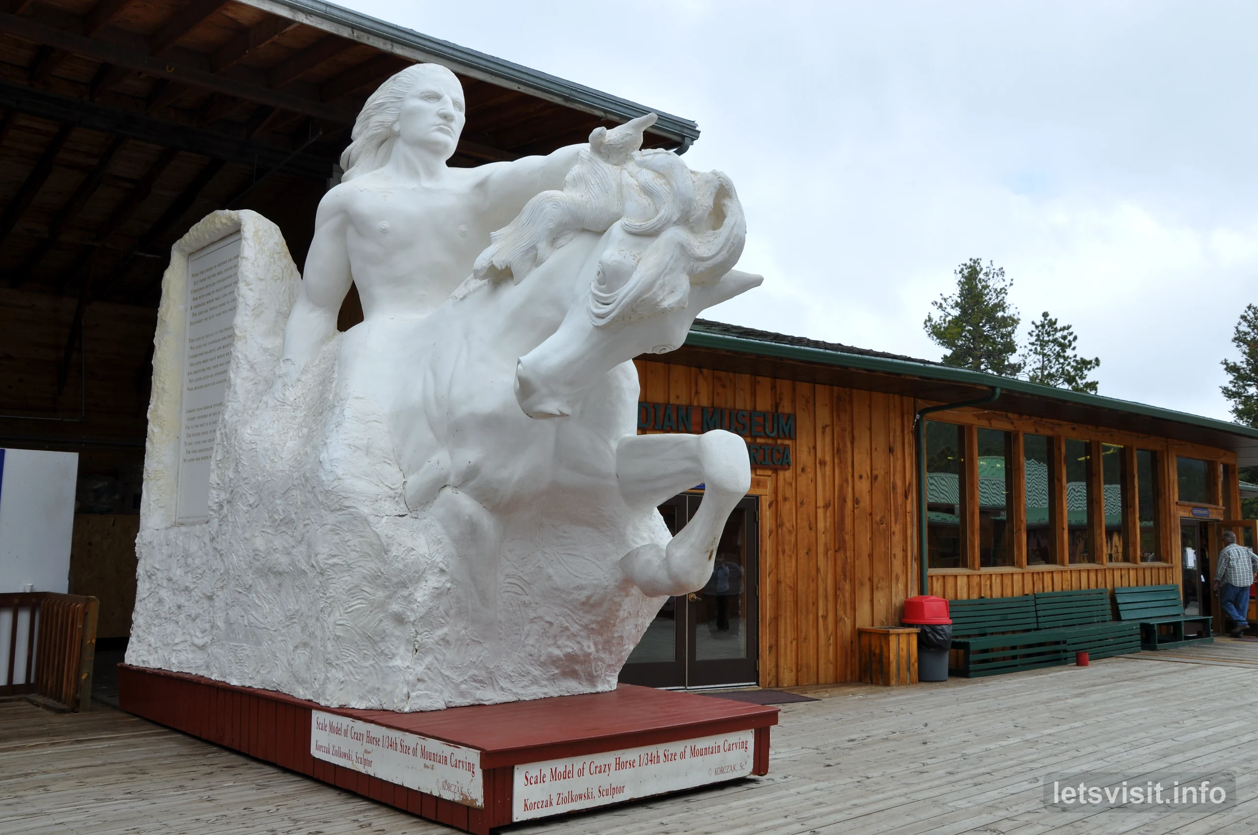
Our next memorial visit offered a different view of a mountain being transformed. At Crazy Horse Memorial, the carving was still visibly a work in progress. Inside the visitor center, a scale model showed the intended finished composition.
Seeing the model helped us understand the mountain outside. It brought the planned figure and horse together in a form that could be taken in at once, while the actual rock still showed how much remained to be done. The comparison between those two views was the most revealing part of the visit.
The project honors the Lakota leader Crazy Horse. Its origins lie in Henry Standing Bear’s invitation to sculptor Korczak Ziolkowski in 1939. Work on the mountain began in 1948, and Crazy Horse’s face was completed and dedicated in 1998. Those milestones are documented in the memorial’s historical timeline.
In 2010, the completed face stood above a larger composition that was still unfinished.
Crazy Horse was conceived as a privately supported undertaking. The foundation describes admissions and private donations as its sources of support. That approach forms part of the project’s history, alongside the long sequence of work on the mountain.
We also spent time looking at paintings and dreamcatchers on display. These smaller objects gave the indoor visit a different focus from the monumental scale outside. The mountain, the model and the exhibits each offered something distinct to examine.
When the rain turned to spring snow
Back on the bus, the weather became the main event. Rain covered the windshield during the onward mountain journey. Then it changed to snow, and the view outside became much harder to make out.
This was a spring tour, yet the snowfall was heavy enough to turn the landscape into an almost continuous white scene. The mountains and road surroundings that usually give a journey its sense of distance were obscured. For that stretch, what we could see was shaped by the weather immediately around the bus.
The contrast with the memorial visit was striking. At Mount Rushmore, mist had partly hidden a single destination. Here, the snow affected the whole view from the moving vehicle.
Conditions later cleared, and the wider landscape came back into view as our journey through Wyoming continued. The sequence of rain, snow and improving visibility became one of the most vivid memories of the road.
A Wyoming motel with an unexpected lobby
Our overnight stop in Wyoming began with a straightforward motel room: a bed, a small table and somewhere to rest after a long day on the road. The room itself gave little indication of what we would find in the lobby.
There, the interior was filled with taxidermy displays. A group of lions, a rhinoceros, an antelope and an ostrich turned the space into something closer in appearance to an exhibition than a conventional reception area.
The animals were arranged as scenes, with the larger specimens dominating the room. Their size and variety made the contrast with our simple accommodation especially noticeable. We had come in for an overnight stay and found ourselves looking around an elaborate collection.
It was one of the less predictable parts of the journey. The famous monuments were the obvious landmarks, but this unusual interior gave our Wyoming stop a character of its own. It also added a very different set of images to the roads, mountains and memorials in our film.
Through Shoshone Canyon and its tunnels
Our onward route took us through Shoshone Canyon, where steep rock walls enclosed the road and the river. The tunnels cut into the mountainside made the close relationship between the route and the terrain particularly clear.
West of Cody, the road follows the Shoshone River between Rattlesnake and Cedar mountains. The Wyoming Department of Transportation’s scenic-byway description places the canyon, Buffalo Bill Dam and the reservoir along this westward corridor.
Traveling through the tunnels, we saw the view narrow and open again. The rock was close beside the road, with the river providing a line through the canyon. This was one of the stretches where traveling between destinations supplied a substantial part of the scenery.
The road then brought the dam and the much broader reservoir into view, changing the character of the landscape again.
Buffalo Bill Dam and the reservoir
Buffalo Bill Dam brought a substantial piece of engineering into the journey. We saw the dam and the reservoir it created, with the water spreading through a landscape enclosed by mountains.
The concrete arch dam was completed in 1910, a century before our visit. At its original height of 325 feet, it was the world’s highest dam when completed. Its central purpose was to store water for irrigation, helping support agriculture in the surrounding region. The National Park Service’s history of the dam explains that early role.
Originally called Shoshone Dam, it received the Buffalo Bill name in 1946, honoring William F. Cody. The structure had also been raised by 25 feet during a later enlargement, before our journey, so the dam we saw was taller than the original 1910 structure.
The reservoir gave the view a different scale from the confined canyon. Water occupied a large part of the landscape, with the road continuing beside it. Knowing why it was there added another dimension to the scenery: this was a working reservoir within a region shaped by the need to manage water.
Wapiti Valley, toward Yellowstone
The final stretch of this part of our journey followed Wapiti Valley, with snow-capped peaks of the Absaroka Range in the distance. The road, river and mountains provided the setting as we continued toward Yellowstone’s eastern entrance.
This corridor follows the North Fork of the Shoshone River. The Buffalo Bill Cody Scenic Byway runs through the valley toward the park, bringing the approach itself into the experience of traveling through northwestern Wyoming.
For us, the snowy peaks and the river made a fitting final landscape for this stage. The weather had changed repeatedly during the journey, and snow was now visible on the distant mountains rather than filling the view immediately outside the bus.
What stayed with us from this journey
Mount Rushmore in the fog is the defining image of our Black Hills visit. The Avenue of Flags led toward a monument whose familiar faces gradually became visible, giving us a view shaped as much by the weather as by the carving.
Other moments were just as specific to the journey: comparing Crazy Horse’s model with the unfinished mountain, watching rain turn to snow from the bus, and finding an extraordinary collection of animals in a motel lobby.
The road through Wyoming tied those experiences to a wider landscape. Shoshone Canyon, Buffalo Bill Reservoir and Wapiti Valley made the traveling itself memorable, carrying this part of our 2010 trip onward toward Yellowstone.
Photos & video: Original material from our spring 2010 journey through the Black Hills and Wyoming — Let’s Visit by Radon.